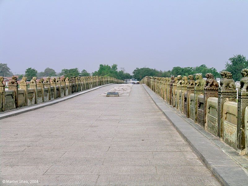
When you leave the City of Cambaluc and have ridden ten miles, you come to a very large river which is called PULISANGHIN, and flows into the ocean, so that merchants with their merchandise ascend it from the sea. Over this River there is a very fine stone bridge, so fine indeed, that it has very few equals. The fashion of it is this: it is 300 paces in length, and it must have a good eight paces of width, for ten mounted men can ride across it abreast. It has 24 arches and as many water-mills, and 'tis all of very fine marble, well built and firmly founded. Along the top of the bridge there is on either side a parapet of marble slabs and columns, made in this way. At the beginning of the bridge there is a marble column, and under it a marble lion, so that the column stands upon the lion's loins, whilst on the top of the column there is a second marble lion, both being of great size and beautifully executed sculpture. At the distance of a pace from this column there is another precisely the same, also with its two lions, and the space between them is closed with slabs of grey marble to prevent people from falling over into the water. And thus the columns run from space to space along either side of the bridge, so that altogether it is a beautiful object.[NOTE 2]
NOTE 1.--[When Marco leaves the capital, he takes the main road, the "Imperial Highway," from Peking to Si-ngan fu, via Pao-ting, Cheng-ting, Hwai-luh, Taï-yuan, Ping-yang, and T'ung-kwan, on the Yellow River. Mr. G. F. Eaton, writing from Han-chung (Jour. China Br. R. As. Soc. XXVIII. No. 1) says it is a cart-road, except for six days between Taí-yuan and Hwai-luh, and that it takes twenty-nine days to go from Peking to Si-ngan, a figure which agrees well with Polo's distances; it is also the time which Dr. Forke's journey lasted; he left Peking on the 1st May, 1892, reached Taï-yuan on the 12th, and arrived at Si-ngan on the 30th (Von Peking nach Ch'ang-an). Mr. Rockhill left Peking on the 17th December, 1888, reached T'aï-yuan on the 26th, crossed the Yellow River on the 5th January, and arrived at Si-ngan fu on the 8th January, 1889, in twenty-two days, a distance of 916 miles. (Land of the Lamas, pp. 372-374.) M. Grenard left Si-ngan on the 10th November and reached Peking on the 16th December, 1894 = thirty-six days; he reckons 1389 kilometres = 863 miles. (See Rev. C. Holcombe, Tour through Shan-hsi and Shen-hsi in Jour. North China Br.R.A.S.N.S. X. pp. 54-70.)--H.C.]
[Illustration: The Bridge of Pulisanghin. (From the Livre des Merveilles.)]
NOTE 2.--Pul-i-Sangín, the name which Marco gives the River, means in Persian simply (as Marsden noticed) "The Stone Bridge." In a very different region the same name often occurs in the history of Timur applied to a certain bridge, in the country north of Badakhshan, over the Wakhsh branch of the Oxus. And the Turkish admiral Sidi 'Ali, travelling that way from India in the 16th century, applies the name, as it is applied here, to the river; for his journal tells us that beyond Kulíb he crossed "the River Pulisangin."
We may easily suppose, therefore, that near Cambaluc also, the Bridge, first, and then the River, came to be known to the Persian-speaking foreigners of the court and city by this name. This supposition is however a little perplexed by the circumstance that Rashiduddin calls the River the Sangín and that Sangkan-Ho appears from the maps or citations of Martini, Klaproth, Neumann, and Pauthier to have been one of the Chinese names of the river, and indeed, Sankang is still the name of one of the confluents forming the Hwan Ho.
[By Sanghin, Polo renders the Chinese Sang-kan, by which name the River Hun-ho is already mentioned, in the 6th century of our era. Hun-ho is also an ancient name; and the same river in ancient books is often called Lu-Kou River also. All these names are in use up to the present time; but on modern Chinese maps, only the upper part of the river is termed Sang-Kan ho, whilst south of the inner Great Wall, and in the plain, the name of Hun-ho is applied to it. Hun ho means "Muddy River," and the term is quite suitable. In the last century, the Emperor K'ien-lung ordered the Hun-ho to be named Yung-ting ho, a name found on modern maps, but the people always call it Hun ho (Bretschneider, Peking, p. 54.)--H.C.]
The River is that which appears in the maps as the Hwan Ho, Hun-ho, or Yongting Ho, flowing about 7 miles west of Peking towards the south-east and joining the Pe-Ho at Tientsin; and the Bridge is that which has been known for ages as the Lu-kou-Kiao or Bridge of Lukou, adjoining the town which is called in the Russian map of Peking Feuchen, but in the official Chinese Atlas Kung-Keih-cheng. (See Map at ch. xi. of Bk. II. in the first Volume.) ["Before arriving at the bridge the small walled city of Kung-ki cheng is passed. This was founded in the first half of the 17th century. The people generally call it Fei-ch'eng" (Bretschneider, Peking, p. 50.)--H.C.] It is described both by Magaillans and Lecomte, with some curious discrepancies, whilst each affords particulars corroborative of Polo's account of the character of the bridge. The former calls it the finest bridge in China. Lecomte's account says the bridge was the finest he had yet seen. "It is above 170 geometrical paces (850 feet) in length. The arches are small, but the rails or side-walls are made of a hard whitish stone resembling marble. These stones are more than 5 feet long, 3 feet high, and 7 or 8 inches thick; supported at each end by pilasters adorned with mouldings and bearing the figures of lions.... The bridge is paved with great flat stones, so well joined that it is even as a floor."
Magaillans thinks Polo's memory partially misled him, and that his description applies more correctly to another bridge on the same road, but some distance further west, over the Lieu-li Ho. For the bridge over the Hwan Ho had really but thirteen arches, whereas that on the Lieu-li had, as Polo specifies, twenty-four. The engraving which we give of the Lu-kou K'iao from a Chinese work confirms this statement, for it shows but thirteen arches. And what Polo says of the navigation of the river is almost conclusive proof that Magaillans is right, and that our traveller's memory confounded the two bridges. For the navigation of the Hwan Ho, evenwhen its channel is full, is said to be impracticable on account of rapids, whilst the Lieu-li Ho, or "Glass River," is, as its name implies, smooth, and navigable, and it is largely navigated by boats from the coal-mines of Fang-shan. The road crosses the latter about two leagues from Cho-chau.
(See next chapter.)
From:
THE TRAVELS OF MARCO POLO: VOLUME II. THE COMPLETE YULE-CORDIER EDITION. IN TWO VOLUMES. Including the unabridged third edition (1903) of Henry Yule's annotated translation, as revised by Henri Cordier; together with Cordier's later volume of notes and addenda (1920)
PROJECT GUTENBERG