 |
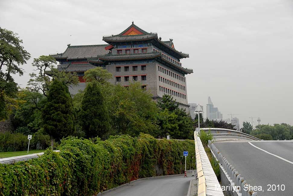
| In this section we will take a tour of the various gates that gave access to the fortified city of Beijing. We will start with the restored gate at Dongbianmen and proceed to the past to see the rest of the gates during the late 1800s and early 1900s. The gates had different characters and different functions. Deliveries of grain were made at one gate and meat to another. The supporting businesses clustered around the gates to fascilitate trade.
Below, there is a map of the central part of Beijing drawn by British cartographers in 1927. The areas in blue are outside the city walls. The various temples have been highlighted with yellow. The Temple of Earth (Ditan) in the north, the Temple of the Sun in the east, and the Temple of the Moon in the west are all outside the city walls. The Temple of Heaven (Tian Tan) and the Temple of Agriculture are both within the city walls in the south section of the city. At the time that the map was drawn, the Republic of China had been founded and the Qing Dynasty had ended. The cartographer indicated the Qing Dynasty names for the sections of the city. The upper brown section was called the Tartar City because only the Manchus, the rulers of China during the Qing Dynasty, were allowed to live there. The lower part of the brown section was known as the Outer City. Chinese were allowed to live there and build their business, most of which were necessary to the running of the imperial households. The lighter portion in the center of the upper brown section is the Forbidden City, the imperial palace. The grounds included rivers and a good sized lake with an island. Today, only a third of the area is open to visitors. The west portion is used for government offices and residences. Mao Zedong lived there. The Forbidden City measures 1 mile (1.7 km) from the north to the south and roughly 1.1 miles (1.8 km) from the east to the west. The entire fortified city meansures roughly 5.3 miles (8.6 km) from the north to the south and 5 miles (8.1 km) from the east to the west at its widest point. To give you an easy reference, the Temple of Heaven in the south measures .9 mile (1.6 km) by 1 mile (1.7 km), but the area shown on the map below is slightly larger - 1.1 miles by 1.2 miles. Dongbianmen is marked with a large red X. A version of the map will be included for each of the gates as you go through the pages. |
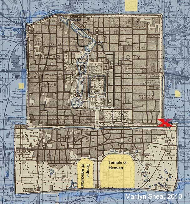 British map drawn 1927. Library of Congress Geography and Map Division Washington (color added) |
Jump to a gate......
Dongbian Men 东便门
Guangqumen 广渠门
Zuo'anmen 左安门
Yongdingmen 永定门
You'anmen 右安门
Guang'anmen 广安门
Fuchengmen 阜成门
Xizhimen 西直门
Deshengmen 德胜门
Andingmen 安定门
Dongzhimen 东直门
Chaoyangmen 朝阳门
Chongwenmen 崇文门
Zhengyangmen 正阳门
China Index >> Historic Beijing >> Beijing City Wall
Click on a picture or use the arrows at the top to navigate through the site.
http://hua.umf.maine.edu/China/beijing2.html
Last update: May 2011
© Marilyn Shea, 2011